Video 13: python part 6 - processing gps data
Table of Contents
Introduction
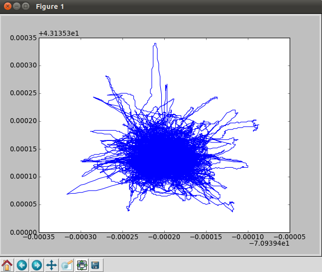
This video covers a first pass at converted a NMEA log from an Airmar weather station into a plot of the wander of the GPS position. The python code is not what I would want to have in the long run, but it is similar to what I might write as a first pass to make sure I know how parse the data and that my results make sense.
The notes for this video are not very polished. You might want to take a look at the bottom section that is a dump of the history from ipython after I produced the video.
Setup
wget http://vislab-ccom.unh.edu/~schwehr/Classes/2011/esci895-researchtools/examples/ccom-airmar-2011-10-11.bz2
bunzip2 ccom-airmar-2011-10-11.bz2
Inspect what we have got
wc -l ccom-airmar-2011-10-11
881046 ccom-airmar-2011-10-11
head ccom-airmar-2011-10-11
# START LOGGING UTC seconds since the epoch: 1318291200.14
# SPEED:       4800
# PORT:        /dev/ttyS0
# TIMEOUT:     300.0
# STATIONID:   ccom-airmar
# DAEMON MODE: False
$PNTZNT,1318291200.14,127.0.0.1,148.167.132.201,3,1318289568.2,0.000034,-20,0.086365,0.052994*12,ccom-airmar,1318291200.14
$GPVTG,277.9,T,293.3,M,0.1,N,0.1,K,D*26,rccom-airmar,1318291200.14
$WIMWV,307.3,R,0.7,N,A*23,rccom-airmar,1318291200.17
$GPZDA,000000,11,10,2011,00,00*4B,rccom-airmar,1318291200.27
What types of NMEA strings do we have?
grep '^\$' ccom-airmar-2011-10-11 | cut -d, -f1 | sort -u
$GPGGA
$GPVTG
$GPZDA
$HCHDT
$PNTZNT
$WIMDA
$WIMWD
$WIMWV
We can look up the NMEA sentences here:
http://gpsd.berlios.de/NMEA.html
=== GGA - Global Positioning System Fix Data ===

Time, Position and fix related data for a GPS receiver.

------------------------------------------------------------------------------
                                                      11
        1         2       3 4        5 6 7  8   9  10 |  12 13  14   15
        |         |       | |        | | |  |   |   | |   | |   |    |
 $--GGA,hhmmss.ss,llll.ll,a,yyyyy.yy,a,x,xx,x.x,x.x,M,x.x,M,x.x,xxxx*hh<CR><LF>
------------------------------------------------------------------------------

Field Number:

1. Universal Time Coordinated (UTC)
2. Latitude
3. N or S (North or South)
4. Longitude
5. E or W (East or West)
6. GPS Quality Indicator,
     - 0 - fix not available,
     - 1 - GPS fix,
     - 2 - Differential GPS fix
           (values above 2 are 2.3 features)
     - 3 = PPS fix
     - 4 = Real Time Kinematic
     - 5 = Float RTK
     - 6 = estimated (dead reckoning)
     - 7 = Manual input mode
     - 8 = Simulation mode
7. Number of satellites in view, 00 - 12
8. Horizontal Dilution of precision (meters)
9. Antenna Altitude above/below mean-sea-level (geoid) (in meters)
10. Units of antenna altitude, meters
11. Geoidal separation, the difference between the WGS-84 earth
     ellipsoid and mean-sea-level (geoid), "-" means mean-sea-level
     below ellipsoid
12. Units of geoidal separation, meters
13. Age of differential GPS data, time in seconds since last SC104
     type 1 or 9 update, null field when DGPS is not used
14. Differential reference station ID, 0000-1023
15. Checksum
Can we load in the GPS GGA messages?
One NMEA GPS location message looks like this:
$GPGGA,000000,4308.1250,N,07056.3750,W,2,9,1.1,35.7,M,,,,*04
Start ipython with ipython –pylab
!head -20000 ccom-airmar-2011-10-11 | tail
$HCHDT,26.2,T*1F,rccom-airmar,1318293159.77
$WIMWV,214.5,T,0.3,N,A*24,rccom-airmar,1318293159.84
$WIMWV,218.9,R,0.3,N,A*22,rccom-airmar,1318293159.89
$HCHDT,26.1,T*1C,rccom-airmar,1318293160.17
$GPVTG,268.5,T,283.9,M,0.1,N,0.1,K,D*2F,rccom-airmar,1318293160.25
$WIMWV,211.9,R,0.4,N,A*2C,rccom-airmar,1318293160.3
$GPZDA,003240,11,10,2011,00,00*4E,rccom-airmar,1318293160.39
$WIMDA,30.1915,I,1.0224,B,17.6,C,,,,,,,229.0,T,244.4,M,0.3,N,0.2,M*2E,rccom-airmar,1318293160.52
$GPGGA,003240,4308.1263,N,07056.3750,W,2,9,1.1,41.3,M,,,,*06,rccom-airmar,1318293160.65
$WIMWD,228.9,T,244.3,M,0.3,N,0.2,M*5B,rccom-airmar,1318293160.74

line = '$GPGGA,003240,4308.1263,N,07056.3750,W,2,9,1.1,41.3,M,,,,*06,rccom-airmar,1318293160.65'
'GGA' in line
'VTG' in line
#!/usr/bin/env python

num_gga = 0

for line in open('ccom-airmar-2011-10-11'):
    if 'GGA' not in line:
        # Skip all lines that are not GPS position messages
        continue
    num_gga += 1

print num_gga
line = '$GPGGA,003240,4308.1263,N,07056.3750,W,2,9,1.1,41.3,M,,,,*06,rccom-airmar,1318293160.65'
fields = line.split(',')
y = int(fields[2][:2]) + float(fields[2][2:])/ 100.
if fields[3] == 'S':
    y = -y
x = int(fields[4][:3]) + float(fields[4][3:]) / 100.
if fields[5] == 'W':
    x = -x
return '%f, %f' % (x,y)
#!/usr/bin/env python

num_gga = 0

X = []
Y = []

for line_num, line in enumerate(open('ccom-airmar-2011-10-11')):
    if line_num > 100:
        break
    if 'GGA' not in line:
        # Skip all lines that are not GPS position messages
        continue
    fields = line.split(',')
    y = int(fields[2][:2]) + float(fields[2][2:])/ 100.
    if fields[3] == 'S':
        y = -y
    x = int(fields[4][:3]) + float(fields[4][3:]) / 100.
    if fields[5] == 'W':
        x = -x
    #print x,y
    X.append(x)
    Y.append(y)
#!/usr/bin/env python

def load_gga(filename):
    num_gga = 0

    X = []
    Y = []

    for line_num, line in enumerate(open(filename)):
        #if line_num > 100:
        #    break
        if 'GGA' not in line:
            # Skip all lines that are not GPS position messages
            continue
        fields = line.split(',')
        y = int(fields[2][:2]) + float(fields[2][2:])/ 100.
        if fields[3] == 'S':
            y = -y
        x = int(fields[4][:3]) + float(fields[4][3:]) / 100.
        if fields[5] == 'W':
            x = -x
        X.append(x)
        Y.append(y)

    return X, Y
x,y = wx2.load_gga('ccom-airmar-2011-10-11')
plot
history
ls -F -l
run wx1
head ccom-airmar-2011-10-11
head -15 ccom-airmar-2011-10-11

line = '$GPGGA,000000,4308.1250,N,07056.3750,W,2,9,1.1,35.7,M,,,,*04,rccom-airmar,1318291200.53'
line
'GGA' in line
'MWD' in line

junk = '$WIMWD,338.0,T,353.4,M,0.6,N,0.3,M*56,rccom-airmar,1318291200.61'
'GGA' in junk
'MWD' in junk
'GGA' in line
'GGA' not in line
'GGA' not in junk

line
line = '$GPGGA,000000,4308.1250,N,07056.3750,W,2,9,1.1,35.7,M,,,,*04,rccom-airmar,1318291200.53'

line.split(',')
fields[2]
fields = line.split(',')
whos

# Latitude
fields[2]
fields[2][:2]
int(fields[2][:2])
fields[2][2:]
float(fields[2][2:])
float(fields[2][2:])/60.
int(fields[2][:2]) + float(fields[2][2:])/60.
fields
run wx1.py

# Longitude
fields
fields[4]
fields[4][:3]
int(fields[4][:3])
fields[4][3:]
float(fields[4][3:])
float(fields[4][3:]) / 60.
int(fields[4][:3]) + float(fields[4][3:]) / 60.

run wx1.py

import wx2
?wx2.load_gga
wx2.load_gga('ccom-airmar-2011-10-11')
_ip.magic("whos")
reload(wx2)
wx2.load_gga('ccom-airmar-2011-10-11')

x,y = wx2.load_gga('ccom-airmar-2011-10-11')
len(x)
print x
plot(x,y)
average(x)
average(y)
The plot
Date: <2011-10-15 Sat>
HTML generated by org-mode 7.4 in emacs 23